Adventure awaits RV travelers who explore British Columbia and Yukon via the Alaska Highway.
By Grace Grogan, F476047
March 2024
Many confuse Dawson Creek, British Columbia, and Dawson City, Yukon, as the same location, but you must drive the 1,202 miles (1,934 kilometers) between them to visit both.
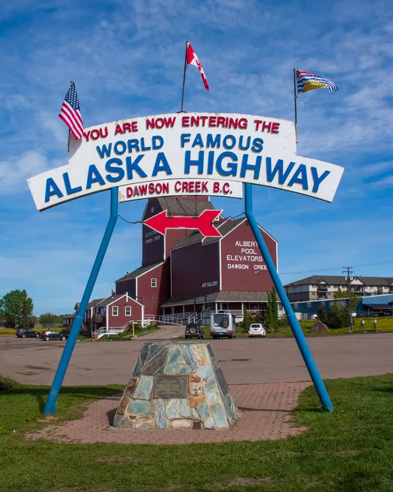
Dawson Creek is located at Mile 0 of the Alaska Highway; construction on what was first known as the Alcan Highway (Alaska-Canada) began from this spot in 1942. In 1941 the town was home to roughly 500 residents, but with the arrival of the Alcan Highway, the population grew to over 3,500 by 1951. The town was named for geologist George Mercer Dawson, who was part of an 1879 survey team seeking passage for the Canadian Pacific Railway.
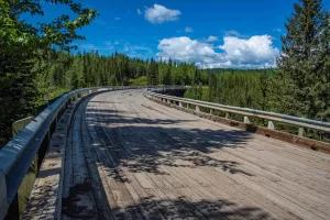
The Kiskatinaw Bridge is a picturesque landmark along the original Alaska Highway near Dawson Creek.
Don’t miss two significant landmarks. Erected in 1946, Milepost 0 sits in the center of a downtown intersection. There is also the Mile “0” cairn and arch, where a large sign commemorates the beginning of the Alaska Highway. This is a more accessible photo-op location that shares parking with the visitor center, the Dawson Creek Art Gallery, and the Northern Alberta Railway Station Museum.
If you love Elvis Presley, grab breakfast at Stuie’s Diner, a 1950s café full of memorabilia. Afterward, head downtown to view murals that depict city history and the Alaska Highway construction on the buildings of various businesses. Explore Walter Wright Pioneer Village, where you experience old-time living, visit original buildings, and gain knowledge about Alaska Highway construction.
The historic Kiskatinaw Bridge was built between 1942 and 1943 as part of the original Alaska-Canada Highway. The three-span timber-truss bridge has a 90-degree curve, measures 534 feet long, and sits 100 feet above the water. Because of landslides below, the bridge was closed to traffic on June 4, 2021, but it can be viewed from either end. Drive to the site in your towed or towing vehicle; there is no room for an RV to turn around.
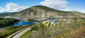
A view of Dawson City, Yukon.
After exploring the city, my partner, Paul Cannon, and I headed west on the Alaska Highway. Before traveling, pick up a copy of The Milepost (themilepost.com). Updated yearly, it covers over 15,000 miles in western Canada and Alaska. Mile-by-mile information includes historical sights, rest areas, campgrounds, fuel stations, restaurants, and more. We referred to it throughout our trip. The 2024 version of the guide is scheduled for release in April.
WATSON LAKE, YUKON
Keep alert and have your camera handy. On our first day driving the Alaska Highway, we spotted a herd of bison, a red fox, a deer, and two black bears. In addition to wildlife, you will experience waterfalls, lakes, and scenic views.
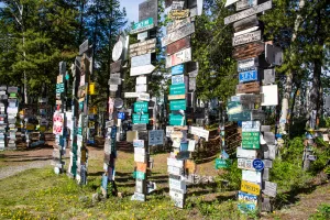
The Sign Post Forest in Watson Lake notes the distance to travelers’ hometowns.
We booked a two-night stay at Baby Nugget RV Park in Watson Lake. The town is named after Frank Watson, an American-born prospector and trapper. There are three unique spots to visit in the area.
The Sign Post Forest is a famous landmark. It began in 1942 when a homesick soldier put up a sign noting the distance to his home. Others did the same, and the tradition grew over the years. You can now walk amongst nearly 100,000 signs, and others continue to be added.
The Northern Lights Space & Science Centre is the only place in North America specializing in the aurora borealis. Northern lights are not visible during the summer due to the midnight sun. Paul and I enjoyed a 55-minute movie about this atmospheric phenomenon.
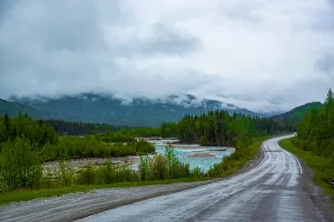
The Alaska Highway passes Summit Lake between Fort Nelson, British Columbia, and Watson Lake.
Watson Lake Cemetery was established in 1950 and contains three fenced sections. Two have white crosses on all graves. The main section is more diverse, including headstones and some graves with black crosses. The property is not well maintained but interesting if you enjoy historic cemeteries.
WHITEHORSE, YUKON
We continued on to Whitehorse, where we spent five nights at Pioneer RV Park & Campground while exploring the area with our towed vehicle. Driving south on the Klondike Highway, we saw beaver houses, a beaver dam, a black bear, at least a dozen roadside waterfalls, and two rapids.
Stop to view Bennett Lake and Emerald Lake, then visit Carcross, one of the oldest villages in the Yukon. Don’t miss the Carcross Desert nearby, which is often called the world’s smallest desert. It features a series of sand dunes that were formed during the last glacial period. Car parking is available; if you have off-road capability, you can drive onto the dunes.
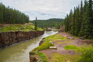
Miles Canyon and the Yukon River viewed from the Robert Lowe Suspension Bridge in Whitehorse.
As the Yukon River cut through a flow of basaltic lava, it created Miles Canyon. From the parking area, walk down the stairs, then along the water to the Robert Lowe Suspension Bridge. This 85-foot-long bridge was built in 1922, crossing the Yukon River at the narrowest part of the canyon. A hiking trail continues across the river. Here, as elsewhere in remote sections of British Columbia, Yukon, and Alaska, carrying bear spray is highly recommended.
The Whitehorse Rapids Fish Ladder is the longest wooden fish ladder in the world. Even when it’s not running, its 1,182-foot length is impressive. The wooden ladder provides safe passage around the Whitehorse Dam turbines for salmon migrating up the Yukon River to spawn.
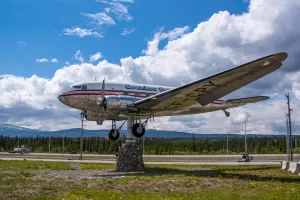
The “World’s Largest Weather Vane” tracks the wind in Whitehorse.
Downtown Whitehorse is filled with historical buildings, including the Old Log Church, whose construction was overseen in 1900 by Yukon’s first Anglican bishop; today it is operated as a museum. Visit the historic S.S. Klondike stern-wheeler. Don’t miss the world’s largest weather vane at the Yukon Transportation Museum: CF-CPY, a Canadian Pacific Airlines DC-3 aircraft mounted on a pedestal that slowly rotates with the wind.
From Whitehorse, many travelers continue west into Alaska. I recommend taking the Klondike Highway north to Dawson City.
DAWSON CITY, YUKON
In June 2022, we encountered three large construction areas on the Klondike Highway. They were wet and muddy. It felt like we were off-roading in our motorhome. If workers are present, a pilot car guides you through. Once work ends for the day, you are on your own. Checking road conditions and construction updates prior to your journey is highly recommended.
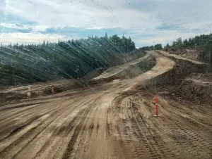
The author encountered road construction along the Klondike Highway.
Some wide construction areas were challenging and not well-marked. We had to determine the best route, not daring to stop, because the mud was sucking at the tires. Other areas were narrow, one-lane sections around curves, where we hoped we didn’t meet oncoming traffic.
We arrived at Bonanza Gold Motel & RV Park in Dawson City late, our vehicles covered in mud, but thanks to the midnight sun, it was light outside. The park has a much-needed RV and car wash.
Dawson City, like Dawson Creek, is named after George Mercer Dawson, the expedition leader of a team exploring the Alaska boundary at the Yukon River in 1887. The town became the heart of the Klondike Gold Rush from 1896 to 1899.
Step back in time as you dine in old hotels, stroll boardwalks, and navigate dirt streets with only an occasional stop sign to be seen. You don’t hear beeping horns, revving engines, or speeding cars. People cross the street where they want to and stop on the road to chat. This popular tourist stop takes life at a slower pace.
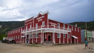
Dawson City’s architecture recalls a golden era.
Most businesses and homes in Dawson City were built during the Klondike Gold Rush, many with five to six steps to get inside. The entire town is grandfathered as being historical, so most businesses are not designed for accessibility. Visit the cabin of poet Robert Service, located at the Dawson Historic Complex National Historic Site, and tour the Jack London Museum & Cabin to glean insights into the American novelist’s life.
I suggest stocking up on groceries before you head into town. During our stay, I climbed the boardwalk and five steps to the Dawson City General Store. There are no grocery carts; the aisles are too narrow to accommodate them. My bill for a loaf of bread, a small package of ribs, two boxes of cereal, and a four-pack of ice cream was $47.66, higher than I expected.
The Bonanza Dining Room in the El Dorado Hotel was the only sit-down restaurant we found that was open for breakfast. If you like grab-and-go, self-serve cafés, you have more options. Many restaurants are open for dinner. Our favorite spot was Sourdough Joe’s, offering great food and large servings. Paul ordered a burger, and his Caesar side salad covered half the plate.
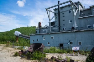
Historic Dredge No. 4 stands in the Klondike Goldfields.
To explore attractions outside of town, you’ll need a towed or towing vehicle. Drive down Bonanza Creek Road to the Klondike Goldfields, site of Dredge No. 4, a national historic landmark and the largest dredge of its type in North America.
Midnight Dome Lookout provides a spectacular view of the city and the Yukon River. Each year on June 21 or 22, locals and visitors participate in a summer solstice tradition that began in the late 1800s. From atop Midnight Dome, there is an illusion of a sunset around 1:00 a.m., when the sun dips behind a mountain for about two hours. The paved road circling the mountain wasn’t built until 1925. I can’t imagine how difficult the 2,911-foot-high climb must have been in the early years for ladies wearing long dresses.
Driving the Dempster Highway from Dawson City into the Northwest Territories has been called a “bucket list” journey.
Dempster Highway is the only drivable road to the Arctic Ocean in Canada. This route is unpaved, lightly traveled, and has no services until the 229-mile halfway point at Eagle Pass. We knew we wouldn’t make it to the halfway point and back in one day, so we watched our gas tank to determine our turnaround point and packed a lunch to eat in the car. It was a fun journey, and we hope to someday drive the entire 458 miles one-way to the Arctic Ocean.
In two floors of exhibits, the Dawson City Museum shares stories of the Klondike and the people who have lived there. One end of the second floor houses the Circuit Court. A sign says court is held every two to three months as needed. The room is open for viewing when not in use.
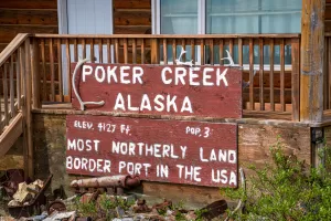
The Poker Creek border crossing connects Yukon to Alaska.
Dawson City residents use the term “one way in, one way out,” but there are actually two routes. To remain in Canada, retrace your steps down the Klondike Highway to the Alaska Highway. If you’re traveling to Alaska, cross the Yukon River on the ferry to drive the Top of the World Highway. The route features 79 miles of mountainous roads with beautiful views, steep downgrades, no guardrails, no shoulders, and pavement that has largely reverted to gravel. You exit the Yukon into Poker Creek, Alaska (population 3), at the most northern border crossing between the two countries. That is the route we took as we continued our travels in Alaska.
PLANNING RESOURCES
For current road advisories and other travel information, check these information sources:
Alaska
dot.alaska.gov/stwdplng/hwysafety/index.shtml
British Columbia
drivebc.ca
Yukon
511yukon.ca
CAMPGROUNDS
Baby Nugget RV Park
Watson Lake, Yukon
nuggetcity.com
(867) 536-2307
Bonanza Gold Motel & RV Park
Dawson City, Yukon
bonanzagold.ca
(867) 993-6789
Reservations: (888) 993-6789
Northern Lights RV Park
Dawson Creek, British Columbia
nlrv.com
(250) 782-9433
Pioneer RV Park & Campground
Whitehorse, Yukon
pioneer-rv-park.com
(867) 668-5944
Reservations: (866) 626-7383