Family RVing Magazine
  • FMCA.COM
  • CONTACT US
familyRVing
  • in this issue
  • tech
    • Tech talk e-newsletter archives
    • more tech talk
  • Digital editions
  • towable guides
  • Classifieds
  • contact
    • contact us
    • advertise with us
    • media room
  • FMCA

Family RVing Magazine

Seven Must-See Stops On The Mohawk Trail

June 1, 2016
Seven Must-See Stops On The Mohawk Trail
The Massachusetts Veterans War Memorial Tower is made from granite mined in the state, and is located at the summit of Mount Greylock.

One of the nation’s oldest auto routes follows an even older path across beautiful northern Massachusetts.

By Karen Lee Ensley
June 2016

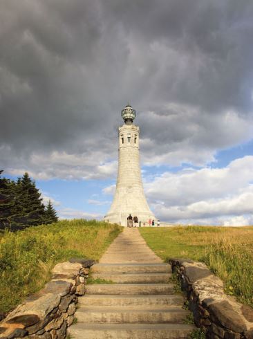
Long before motorhomes were invented, an ancient footpath served as a travel route across what is now northwestern Massachusetts. Known as the Mohawk Trail, the famed path was created more than 10,000 years ago as American Indians walked, hunted, and traded along the region’s winding rivers.

The trail was relocated a bit when European settlers came with their horses and wheeled vehicles. After the advent of cars, in 1914 the Mohawk Trail opened as one of the first auto touring roads in the United States. Today you can use your motorhome’s horsepower to enjoy the picturesque drive past beautiful forests, farmland, and quaint New England towns on your way to or from FMCA’s 94th Family Reunion & Motorhome Showcase, August 3-6, 2016, in West Springfield, Massachusetts.

The Mohawk Trail has various unofficial starting and ending points, but a 69-mile portion of State Route 2 from Williamstown to Athol is designated the Mohawk Trail Scenic Byway. It’s labeled as such along the way by iconic symbols such as a totem pole, a teepee, and a wood-carved American Indian sculpture. As you enjoy the drive, be sure to park the motorhome at the following seven must-see stops (listed from west to east). They represent only some all of the sights, so be sure to obtain a brochure or map from the Mohawk Trail Association listed below.

1. Mount Greylock State Reservation, Lanesborough

What will you see when you view Massachusetts’ tallest mountain, 3,491-foot Mount Greylock, from a distance? Located in the western part of the state, far from the ocean, the mountain surprisingly became the inspiration for the classic novel Moby Dick. Its author, Herman Melville, thought the mountain was shaped like a white whale. For writer and naturalist Henry David Thoreau, Mount Greylock inspired a belief in nature’s spiritual value. After hiking to its peak and spending the night in a makeshift shelter, he awoke to see “an ocean of mist” surrounding the mountain. For him, it was a transcendental experience.
In 1885, local civic leaders purchased 400 acres at the summit for the public’s recreational use. Today Massachusetts’ first state park covers more than 12,500 acres and features a fascinating environment. It encompasses a boreal spruce bog and blueberry barrens, unusual for southern New England. Its subalpine forest is also noteworthy, as these are typically located just below the Arctic Circle.
The origin of Mount Greylock’s name is uncertain; it was derived either from the summit’s frosted winter appearance or from the legendary Indian chief Gray Lock. The park’s stands of old-growth spruce have been designated a National Natural Landmark; the park also hosts 40 species of rare plants and several rare animals, and it contains the commonwealth’s only known nesting site of the blackpoll warbler.
Park the motorhome and take a hike! Choose from more than 70 miles of trails, including an 11 ½-mile section of the Appalachian National Scenic Trail. Or, walk to Money Brook Falls, where counterfeiters minted coins long ago. Notice the paper birch trees; their white bark was used to make bowls and canoes.
At the summit, which is a National Historic District, the fee to park is $6 for out-of-state vehicles and $5 for state residents. But once there, you can admire the 92-foot Veterans War Memorial Tower (being renovated now through 2017) and Bascom Lodge. Depression-era Civilian Conservation Corps workers camped at the site of the present-day campground and built the lodge, as well as the Thunderbolt Ski Trail.
The view from the summit is spectacular. As you gaze over the Berkshire landscape, look for the town of Adams, site of your next stop on the Mohawk Trail.

2. Susan B. Anthony Birthplace Museum, Davis

When a baby girl was born in this home on a cold, wintry night in February 1820, her father said she brought a “presence of light into the world.” Little did anyone know how she would shed light upon the social injustices of her time. She became so influential that her birthplace is known as the Cradle of Equal Rights.
At age 11, Susan left school when she insisted on learning long division, a subject that was for boys only, and was taught in a school set up by her father. Years later, when she attended a meeting of the Sons of Temperance and was told she wasn’t permitted to speak because she was a woman, she helped form the Women’s State Temperance Society of New York, the first of its kind.
Anthony rallied female teachers to demand a salary equal to that of male teachers’ pay. She published a newspaper, The Revolution, promoting such ideals as education for women and the right of women to own property. She even advocated dress reform for women.
She also supported the abolition of slavery; persuaded the University of Rochester to admit women; and, most notably, fought for women’s right to vote. Even though the 19th Amendment was not ratified until 1920 (14 years after her death), Anthony voted in the United States presidential election of 1872, and was arrested for it. At the museum, you’ll learn how she was tried and fined without a jury even getting to discuss the case, and how the fine remained unpaid. Be sure to take the guided tour that passionately brings Susan B. Anthony’s remarkable story to life. The museum is open Thursday through Monday; admission is $6 for adults, $4 for seniors, $3 for students, and free for children 6 and under. Visit www.susanbanthonybirthplace.com or call (413) 743-7121 for details.

Far east along the Mohawk Trail is the Hoosac Gateway Tunnel. 3. Western Gateway Heritage State Park, North Adams

North Adams is nicknamed the Steeple City, and when you see the cluster of iconic New England church steeples, you’ll know why.
The town’s Western Gateway Heritage State Park has beautifully restored buildings that are listed on the National Register of Historic Places. And its visitors center is a hidden gem. Inside are exhibits about the nearby Hoosac Tunnel, one of the greatest engineering feats of the 19th century. An audiovisual presentation provides the sounds of dripping water, explosions, and pickaxes hitting stone as you read about the tunnel’s dangerous construction. In 1851, no one in the country had any experience building long tunnels, yet the proposed Hoosac Tunnel required digging through five kinds of rock for more than 25,000 feet (4.75 miles). Even today, it’s the longest railroad tunnel in North America east of the Rocky Mountains.
It took 25 years to complete, and then the first train that came through caused rocks to fall from the ceiling. The tunnel couldn’t be used until an arch containing 2 million bricks was completed. The work was so deadly that 195 workers lost their lives in the tunnel that became known as the Bloody Pit.
The tunnel is still used by freight trains and the occasional special Amtrak passenger train. Be sure to see the eerie exhibit telling of the legends of ghostly apparitions appearing like miners carrying picks and shovels through a shroud of mist.
Admission to the park and visitors center museum is free.

4. Natural Bridge State Park, North Adams

Turn north onto State Route 8 from the Mohawk Trail (State Route 2) for your next must-see spot. This is a natural wonder, a white marble bridge that began 550 million years ago — with seashells. The only naturally formed white marble arch in North America, the bridge was created when an ancient ocean deposited shells that dissolved into a chalky, calcium carbonate sediment that eventually became rock. Lateral movement of tectonic plates folded the Earth’s crust, and the resulting heat and tremendous pressure on the rock created the white marble you see in the 48-acre park today.
The bridge is 15 feet thick and 30 feet across as it spans the Hudson Brook. As you explore the park, look for names carved into the marble; many date to the 1800s when a quarry operated on the site. Notice the man-made white marble dam; it’s the only one in North America. It was built to power the Hoosac Marble Mill, which produced a variety of by-products, such as paint pigment and powder for toothpaste. Marble from the quarry was used in many buildings in the North Adams area for everything from mantel pieces to windowsills.
The day parking fee is $6 for nonresidents ($5 for residents).

5. Mohawk Trail State Forest, Charlemont

From North Adams, you can continue east on the Mohawk Trail through the famous Hairpin Turn. However, if you’re driving a large motorhome or driving your coach while towing a car, you may wish to avoid it. (Contact the Mohawk Trail Association listed below for more information.) The way around is to drive south to Adams on State Route 8, and then take State Route 116 south to State Route 8A, back up to State Route 2 (the Mohawk Trail) near the town of Charlemont.
Either way, at Mohawk Trail State Forest, you can set foot on many original Indian trails, including a portion of the infamous Mohawk Trail.
This park has more than 6,000 acres of scenic woodlands. As you hike, notice the tall old-growth trees and the diversity of plant and animal life. Stop by a stream for excellent trout fishing, but be sure to allow time to hike to the top of Todd Mountain, where you’ll find the original section of the Mohawk Trail. Take a step on the path and imagine taking a step back in history.
The day parking fee is $10 for nonresidents ($8 residents). RV camping is available at this state forest for vehicles up to 30 feet long. For details, contact the park at (413) 339-5504 or email Mohawk.trail@state.ma.us.

6. Glacial Potholes, Shelburne Falls

A driver usually avoids potholes, but glacial potholes in a river are an intriguing sight, and they won’t damage the motorhome. The potholes were formed after the last glaciers in the region melted, creating a huge lake that covered the Connecticut River Valley. The lake drained into the rushing water of the Deerfield River, causing it to carry a large load of sand and rocks. Stones, trapped in cracks in the riverbed, were spun round and round by the fast-moving water until they wore holes into the hard granite, creating glacial potholes.
One of the largest known concentrations of these geological wonders is located in the Deerfield River near Salmon Falls, in the town of Shelburne Falls. The creative shapes of the potholes seem to blend with the delightfully artistic feel of the town. Look for the potholes below the dam on the river. You can get a good view from the observation deck, but bring binoculars to see the natural grinding stones inside these potholes — they’re still there.
This part of the river has more than 50 potholes; some are as small as 6 inches, and the largest is an astounding 39 feet in diameter.

7. Bridge Of Flowers, Shelburne Falls

What do you do with a 400-foot-long, concrete trolley bridge after the trolley ceases to run? In 1928 Antoinette and Walter Burnham had a vision. If the 1908 bridge could grow weeds, why not plant a bridge of flowers?
Touted as the only one of its kind in the world, the Bridge of Flowers in Shelburne Falls became a reality in 1929. Today it welcomes visitors from around the world. Two memorials set among the beauty offer a patriotic tribute to local veterans.
Like a work of art, the bridge is bordered by a mix of trees, shrubs, vines, and flowers that bloom from April to October. Local volunteers, known as the Blossom Brigade, lovingly tend the plants alongside a head gardener and an assistant. Be sure to stop and smell the roses or any of the more than 500 varieties of annuals and perennials that will delight your senses.
Donations are welcomed and are tax deductible; however, you can take a leisurely stroll across the garden bridge for free. Also, free parking is available in many areas throughout the town. Visit www.shelburnefalls.com for more information.

To The Victors Goes The Name

The Mohawk Trail was used by more than one American Indian tribe, but the name Mohawk prevails thanks to a complex story involving distrust, epidemics, and alliances between Europeans and American Indians. English and Dutch settlers wanted Indian lands, so they pitted one tribe against another. In 1664, the Pocumtuck nation was living primarily in a village in what is now Deerfield, Massachusetts, when they were blamed for the death of a Mohawk with a high tribal standing. In revenge, Mohawk warriors used the ancient trail in February 1665 to reach and successfully destroy the village; so, the path bears their name.
Further Info
Mohawk Trail Association
(866) 743-8127
(413) 743-8127
www.mohawktrail.com
Local tourism information booths can be found in North Adams on Union Street and in Shelburne Falls on Bridge Street.
For general information, contact:
Massachusetts Office of Travel & Tourism
(800) 227-MASS (6277)
(617) 973-8500
www.massvacation.com
Massachusetts state parks have free entry but charge day-use parking fees that vary by the park. You may consider purchasing an annual parks pass: $85 for nonresidents ($60 for residents). For more information about the state parks mentioned here, visit www.mass.gov/massparks.
previous post
President’s Message: Recharged And On The Move
next post
Foretravel ih-45 50th Anniversary Model

You may also like

Rear View: April 2016

April 1, 2016

Executive Director’s Commentary: Our Furry Four-Legged Family Members

February 1, 2016

Family Fun In A Kayak Or Canoe

November 1, 2016

In Search Of Denali

August 1, 2016

Airstream Interstate Grand Tour

June 1, 2016

Family & Friends: Wisconsin Voyagers Mark 25th Anniversary

August 1, 2016

A Small Rig Living Large

September 1, 2016

Finding Fun In Perry

May 1, 2016

Open Mike: A Perfect Day

June 1, 2016

Lighten Up And Take A Hike

May 1, 2016


  • Facebook
  • Twitter
  • Instagram
  • Pinterest
  • Youtube

©2023 - Family Rving Magazine All Rights Reserved.


Back To Top

FMCA members have access to exclusive articles and RV tips, plus a digital library of RVing know-how. For full access to website content, plus must-have travel benefits, join FMCA today and get instant access to Family RVing magazine.

If you already have a membership with us, sign in now to get full access!

Join Now Sign In